
![]() Current volcanic activity
Current volcanic activity
Bulletin N°10- Vanua Lava Activity
|
VANUATU VOLCANO ALERT BULLETIN N°10 - VANUA LAVA ACTIVITY
Thursday October 31st 2024
VANUA LAVA VOLCANO 13°80’S 167°47’E Summit 3021ft (921m) Current Vanuatu Volcano Alert Level: Level 1
Vanua Lava volcano is continuing to show signs of unrest. Vanua Lava Volcanic Alert Level remains at Level 1. Volcanic unrest continues at Vanua Lava. New observations have confirmed that the Vanua Lava volcanic activity is likely to continue at similar levels, consistent with the Volcanic Alert Level 1. The danger zone for life safety is limited around the volcanic area and the sulfur river areas. Latest field observations photos confirmed the ongoing presence of volcanic gases at the volcanic area and around the sulfur river. Volcanic hazards remain at the volcanic cone and areas around the sulfur river. Vanua Lava volcanic alert level has been at Level 1 since 27th May 2016. The current observations are consistent with the Volcanic Alert Level 1 activity. Level 1 indicates “Signs of unrest. The danger zone for life safety is at the volcanic area and the sulfur river areas”. All tourism agencies, visitors, local authorities, and people from Vanua Lava Island and general public are reminded to must NOT approach the volcanic areas and the sulfur river areas. Visitors and communities of Vanua Lava Island will continue to expect the presence of hot springs and volcanic gas when approaching the volcano and sulfuric river areas. Information about volcanic hazards are available at the link below: www.vmgd.gov.vu/vmgd/index.php/geohazards/volcano/volcano-info/resources The Vanuatu Meteorology and Geohazards Department will closely monitor this volcano activity. More information will be provided accordingly when necessary. <div style="text-align: center;"><i>For further information, please contact Geohazards Division at the Vanuatu Meteorology and Geohazards Department at This email address is being protected from spambots. You need JavaScript enabled to view it. or 24686.</i></div> |
Bulletin N°10- Gaua Activity
|
VANUATU VOLCANO ALERT BULLETIN N°10 - GAUA ACTIVITY
Thursday October 31st 2024
GAUA VOLCANO 14°16’0”S 167°30’0”E Summit 2615ft (797m) Current Vanuatu Volcano Alert Level: Level 2
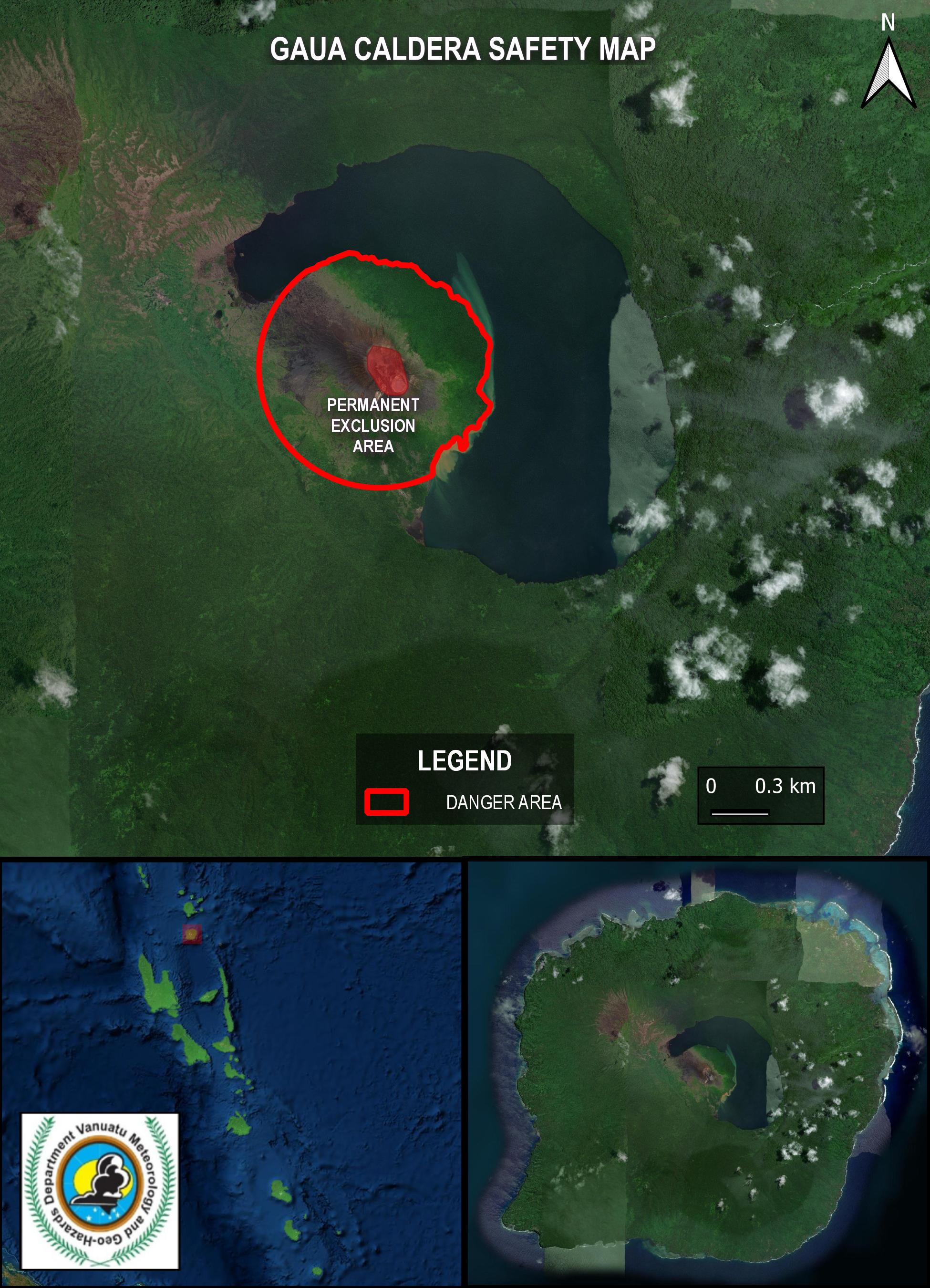
Gaua Volcano is continuing in the major unrest state. Gaua Volcanic Alert Level remains at Level 2. Major volcanic unrest activity continues at Gaua and confined at the active vent at the summit area. Latest field observations have confirmed that Gaua volcanic activity conditions at the major unrest state are unstable. It is likely that its volcanic activity could continue at similar level, consistent with Volcanic Alert Level 2. The danger zone for life safety remain limited to on the volcanic cone. Latest field observations photos taken on 5th October 2024 showed continuing emission of volcanic cloud which may content steam and/or gas. Satellite images confirmed evidence of volcanic degassing during the past days. Volcanic hazards remain at areas around the volcanic cone. Alert Level for Gaua volcano has been at Level 2 since 31st January 2018. The current observations are consistent with the Alert Level 2 activity. Level 2 indicates “Major Unrest. The danger zone is around the Gaua volcanic cone”. With this current volcanic activity, it is a useful reminder that eruptions can occur with little or no warnings. This is a reminder to all tourism agencies, local authorities, people in Gaua and the general public NOT to access areas around the volcanic cone (See Gaua caldera safety map below). In this area volcanic gases will always be expected and other volcano risk could occur at any time in such major unrest state. Gaua volcano visitors will continue to expect volcanic gases while approaching the volcanic cone. Acid rain may be expected at areas around Gaua volcanic cone specially those exposed to prevailing trade winds. Information about volcanic hazards are available at the link below: www.vmgd.gov.vu/vmgd/index.php/geohazards/volcano/volcano-info/resources The Vanuatu Meteorology and Geohazards Department will continue to closely monitor this volcano activity. More information will be provided when necessary.
<div style="text-align: center;"><i><b>Fig. </b>Gaua caldera safety map </i></div><div style="text-align: center;"><i><b><br></b></i></div><div style="text-align: center;"><i> For further information, please contact Geohazards Division at the Vanuatu Meteorology and Geohazards Department at This email address is being protected from spambots. You need JavaScript enabled to view it. or 24686.</i></div> |
Bulletin N°10- Ambae Activity
|
VANUATU VOLCANO ALERT BULLETIN N°10 - AMBAE ACTIVITY
Thursday October 31st 2024
AMBAE VOLCANO 15°24’0”S 167°50’0”E Summit 4908ft (1496m) Current Vanuatu Volcano Alert Level: Level 2
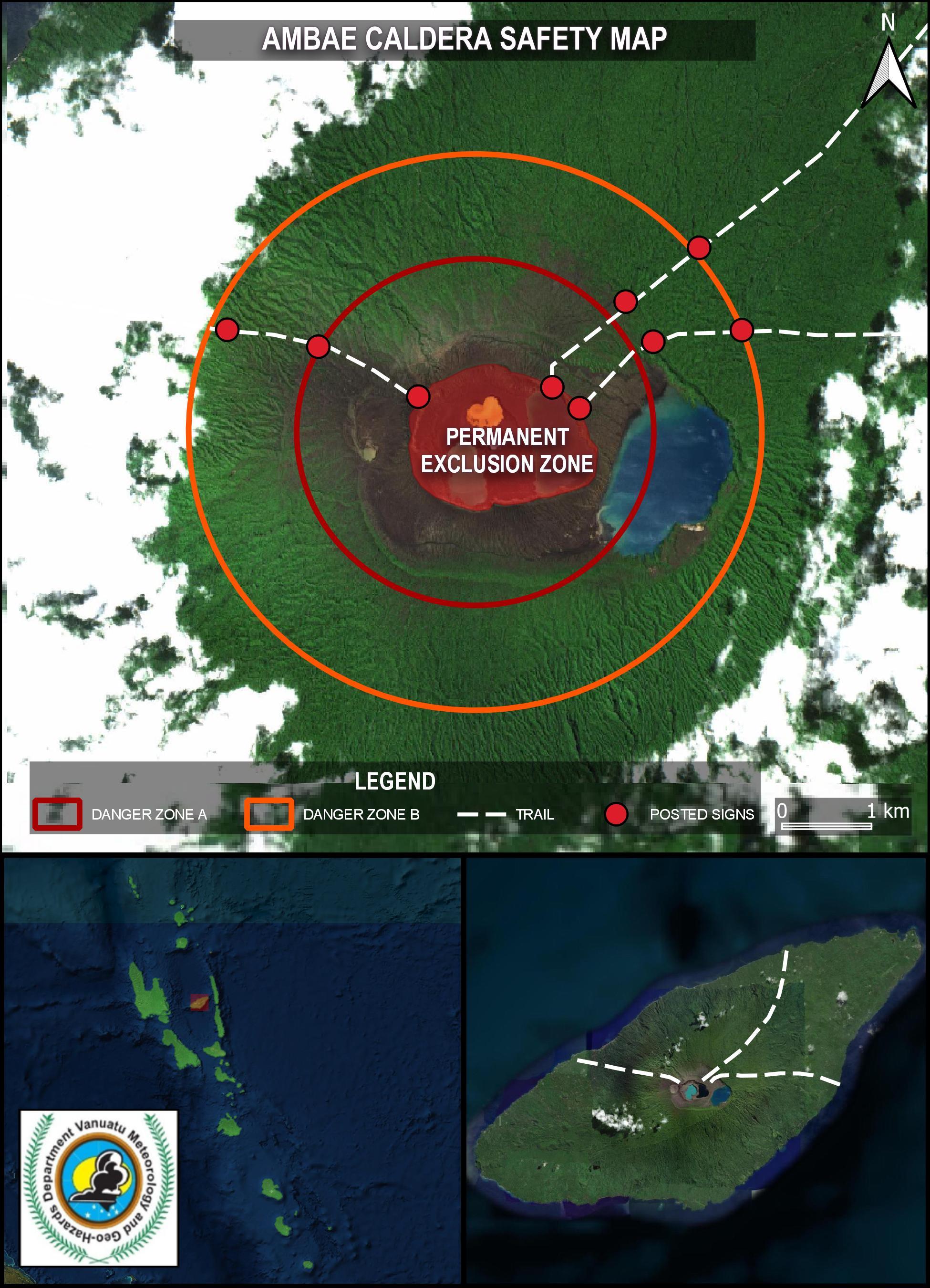
Ambae volcano activity is continuing in the major unrest state. Ambae Volcanic Alert Level remains at Level 2. Major volcanic unrest at Ambae volcano continues and remains confined in Lake Voui. New field observations and data analysis have confirmed that the Ambae volcanic activity conditions at this major unrest state remain unstable. It is likely that its activity continues at this similar level, consistent with Volcanic Alert Level 2. The danger zone for life safety remain limited at 2 km radius from the 2017-2018 active vents and flowing creeks during heavy rain. Field observation photos taken on 5th October 2024 showed continue emissions of volcanic cloud from the volcanic cone in Lake Voui. These volcanic clouds may contain water vapor (steam) and/or gases. Satellite images of the past days showed evidence of continued volcanic degassing. Analysis of seismic data confirmed continuing major volcanic unrest on Ambae. With this ongoing volcanic activity, volcanic hazards remain at the volcano summit area and flowing creeks (e.g. remobilization of remaining ash from 2017 and 2018 eruption). The Ambae volcanic alert level has been at Level 2 since 27th December 2021. Observations of the current activity are consistent with the Volcanic Alert Level 2. Level 2 indicates “Major unrest. The danger zone remains at the Danger Zone A which is about 2 km radius from the 2017-2018 active volcanic vents and within the area of flowing creeks during heavy rain”. With this current volcanic activity, it is a useful reminder that eruptions can occur with little or no warnings. All tourism agencies, local authorities, people on Ambae and the general public are reminded that the danger zone at the summit area remains at the Danger Zone A (See Ambae caldera safety map below) which is approximately about 2 km radius from the 2017-2018 active vents due to the presence of volcanic hazards in this area such as gases and others volcanic activity related risk. Risk is also present in areas of flowing creeks during heavy rain due to the presence of remaining volcanic ash from 2017 and 2018 eruption at the summit areas. Acid rain can be expected at the summit area and villages specially those exposed to prevailing trade winds when the volcanic cloud reaches a few kilometers in height. Villages located near flowing creeks can continually expect changes in stream behavior and larger than normal flow rates during heavy rains. People on Ambae Island need to be aware of the dangerous flows while approaching these creeks during heavy rains. Ambae volcano advice key message and information about volcanic hazards can be found at the link below: http://www.vmgd.gov.vu/vmgd/index.php/geohazards/volcano/volcano-info/resources. The Vanuatu Meteorology and Geohazards Department will continue to closely monitor this volcano activity. More information will be provided when necessary.
<div style="text-align: center;"><i><b>Fig</b>. Ambae caldera safety map </i></div><div style="text-align: center;"><i><br></i></div><div style="text-align: center;"><i><b> Note : </b>« Posted sign » : Signs will be installed later at the locations shown on the above image. </i></div><div style="text-align: center;"><i><br></i></div><div style="text-align: center;"><i> For further information, please contact Geohazards Division at the Vanuatu Meteorology and Geohazards Department at This email address is being protected from spambots. You need JavaScript enabled to view it. or 24686.</i></div> |
Bulletin N°13- Ambrym Activity
|
VANUATU VOLCANO ALERT BULLETIN N°13 - AMBRYM ACTIVITY
Wednesday November 13th 2024
AMBRYM VOLCANO 16°15’00”S 168°07’00”E Summit Elevation 4377ft (1334m) Current Vanuatu Volcano Alert Level: Level 2
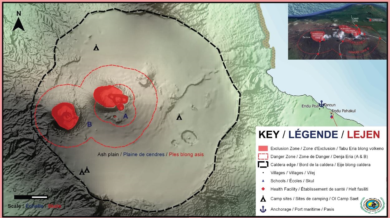
Ambrym volcanic activity is slightly increased in the level of major unrest. Ambrym Volcanic Alert Level remains at Level 2. Analysis of new scientific data has confirmed that that the conditions of volcanic activity in Ambrym remain unstable at major unrest level and identified the extension of new areas at risk. With current volcanic activity, the associated risk zone extends towards the ash plain. Satellite images have detected evidence of low to moderate volcanic thermal anomalies on November 1st, 2nd, 5th, 11th, and 12th, 2024, indicating an increase in surface temperature due to the presence of magma on the Earth's surface. On November 12, 2024, the interferometry radar satellite technique detected a ground deformation of Ambrym volcano, linked to the movement of magma under the caldera. Analysis of seismic data has confirmed ongoing major volcanic activity on Ambrym. Ambrym volcanic alert level remain at Level 2 since 17th January 2024. Observations of the current activity are consistent with the Volcanic Alert Level 2. Level 2 indicates “Major unrest. Major unrest. The danger zone is at the Danger Zone B which is about 2 km radius from Benbow crater and about 3 km radius from Marum crater and towards the ash plain”. All tourism agencies, local authorities, people of Ambrym and the general public are strongly advice DO NOT access the Danger Zone B which is about 2 km radius around Benbow crater and about 3 km radius around Marum crater (including Maben-Mbwelesu, Niri-Mbwelesu and Mbwelesu) (Fig1. Ambrym caldera safety map) and towards the ash plain due to the ground deformation detection in the caldera. With this current volcanic activity, it is a useful reminder that eruptions can occur with little or no warnings. Ambrym volcano advice key message and information about volcanic hazards can be found at the link below: https://www.vmgd.gov.vu/vmgd/index.php/geohazards/volcano/volcano-info/resources. The Vanuatu Meteorology and Geohazards Department continues to closely monitor this volcano activity. More information will be provided as soon as necessary.
<div style="text-align: center;"><i><b>Fig1.</b> Ambrym caldera safety map </i></div><div style="text-align: center;"><i><br></i></div><div style="text-align: center;"><i><br></i></div><div style="text-align: center;"><i> For further information, please contact Geohazards Division at the Vanuatu Meteorology and Geohazards Department at This email address is being protected from spambots. You need JavaScript enabled to view it. or 24686.</i></div> |
Bulletin N°10- Lopevi Activity
|
VANUATU VOLCANO ALERT BULLETIN N°10 - LOPEVI ACTIVITY
Thursday October 31st 2024
LOPEVI VOLCANO 16°30’23”S 169°20’18”E Summit 4635ft (1413m) Current Vanuatu Volcano Alert Level: Level 2
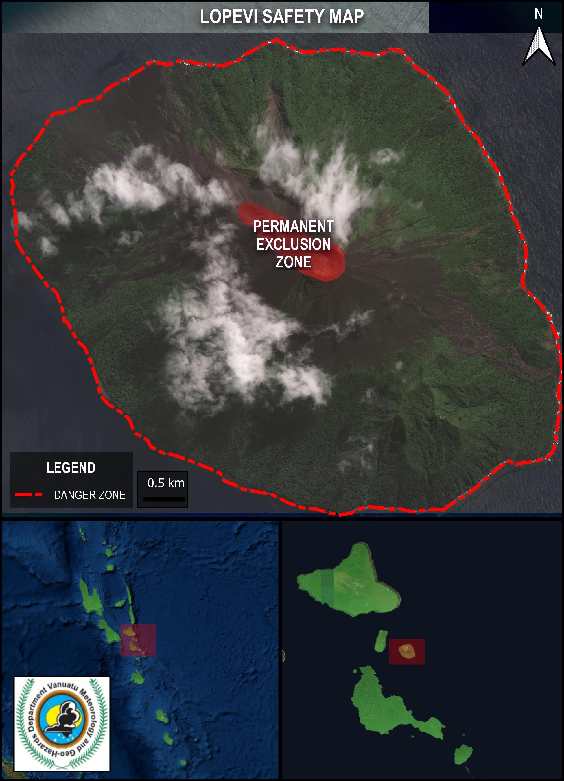
Lopevi volcano is continuing in the major unrest state. Lopevi Volcanic Alert Level remains at Level 2. Major volcanic unrest at Lopevi volcano continues and confined at the active craters near the summit crater. New field observations and data analysis have confirmed that Lopevi volcano conditions at the major unrest state remain unstable. It is likely that its volcanic activity could increase at any time but it could also remain at the same level for a longtime The danger zone for life safety remain limited on the Island of Lopevi. Recent field observation photos via webcam showed continuous emission of small steam plume (fumerole) at the summit crater. On 3rd October 2024, the satellite image have detected evidence of low thermal anomaly around the volcano indicating an increase in surface temperature due to the presence of the magma at the earth surface. Analysis of seismic data confirmed the ongoing major volcanic unrest activity at Lopevi. With this current activity, volcanic hazards remain at the Lopevi Island. In the past, small or short-lived eruptions have followed volcanic unrest at Lopevi. The chance for an eruptive phase to follow the current volcanic unrest, like in January 2017, is likely. Lopevi volcanic alert level has been at Level 2 since 23th September 2017. The current observations are consistent with the activity of the Volcanic Alert Level 2. Level 2 indicates “Major level of unrest. The danger zone for life safety is on the island of Lopevi”. With this current volcanic activity, it is a useful reminder that eruptions can occur with little or no warning. This is a reminder that all visitors to Lopevi may be affected by the volcanic unrest. Authorities, communities from the islands of Paama and Epi, travel agencies, and general public must take this information into consideration while visiting and/or approaching Lopevi Island due to the presence of volcanic hazards at Lopevi Island. Information about volcanic hazards are available at the link below: www.vmgd.gov.vu/vmgd/index.php/geohazards/volcano/volcano-info/resources The Vanuatu Meteorology and Geohazards Department will continue to closely monitor this volcanic activity. More information will be provided when necessary.
<div style="text-align: center;"><br></div><div style="text-align: center;"><i><b>Fig. </b>Lopevi volcano safety map </i></div><div style="text-align: center;"><i><b><br></b></i></div><div style="text-align: center;"><i><b> </b>For further information, please contact Geohazards Division at the Vanuatu Meteorology and Geohazards Department at This email address is being protected from spambots. You need JavaScript enabled to view it. or 24686.</i></div> |
Bulletin N°10- Tanna Activity
|
VANUATU VOLCANO ALERT BULLETIN N°10 - TANNA ACTIVITY
Thursday October 31st 2024
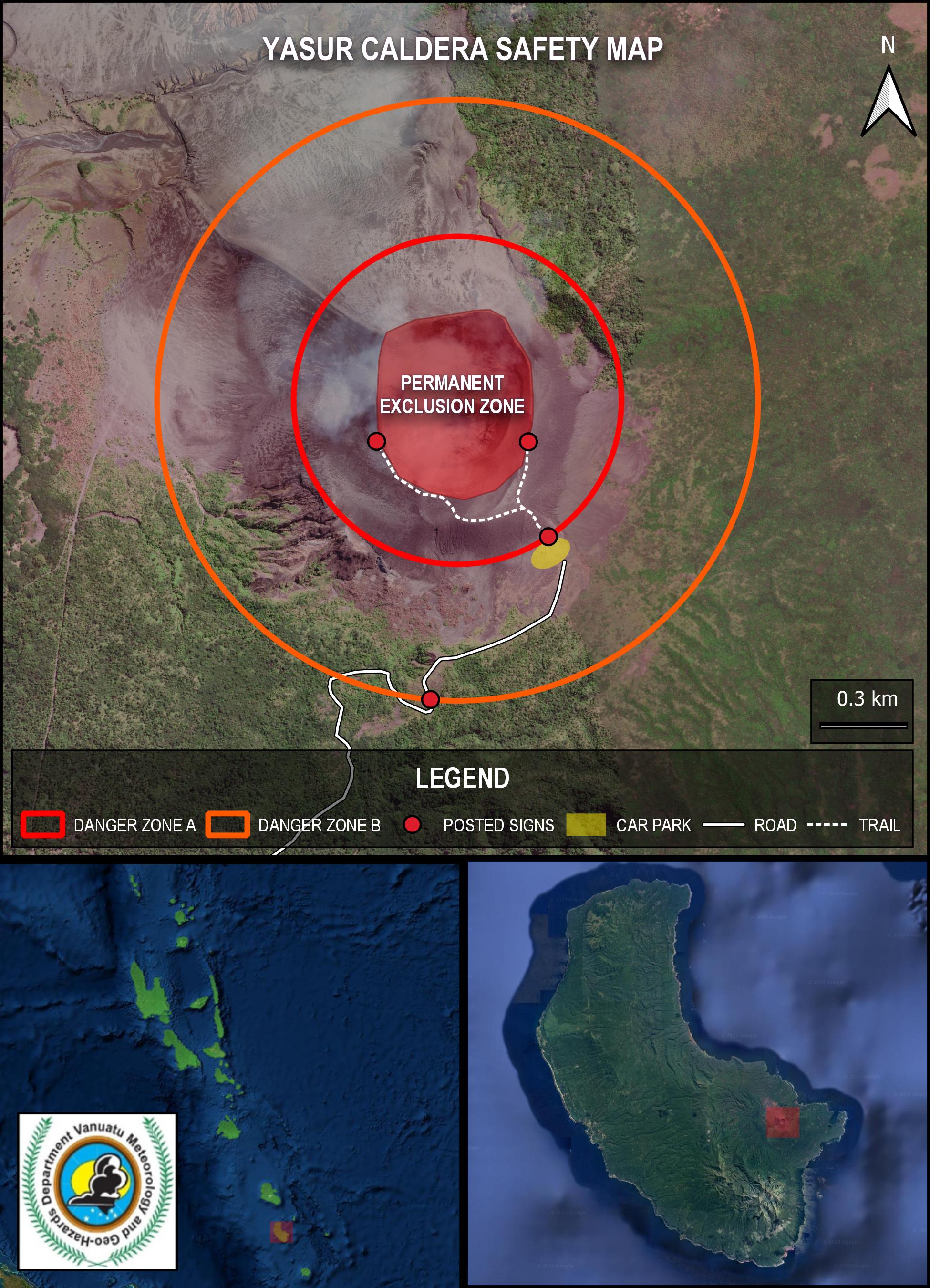
TANNA VOLCANO 19°32’0”S 169°26’30”E Summit 1184ft (361m) Current Vanuatu Volcano Alert Level: Level 2 Yasur volcano is continuing in the major unrest state. Yasur Volcanic Alert Level remains at Level 2. Major volcanic unrest at Yasur continues and confined inside the volcanic crater. New field observations and analysis of data have confirmed that Yasur volcano condition at this major unrest state remain unstable. It is likely that its activity continue at this similar level, consistent with Volcanic Alert Level 2. The danger zone for life safety remain limited at 600 m radius from eruptive vents inside the crater. Recent field observation photos via webcam shown that Yasur volcanic activity consists of continuous explosions with cloud emissions that may contain water vapor (steam) and/or gases and/or ashes from eruptive vents. Satellite images of the past days have confirmed evidence of volcanic degassing and ongoing detection of low to moderate thermal anomalies at Yasur indicating an increase in surface temperature due to the presence of the magma at the earth surface. Analysis of seismic data confirmed the ongoing major volcanic unrest activity continue at Yasur and some explosions remain strong. With this current activity, volcanic hazards remain inside and around the crater rim. Yasur volcanic alert level has been at the Level 2 since 18th October 2016. The current observations are consistent with the Alert Level 2 activity. Level 2 indicates “Major Unrest. The danger zone for life safety remain at the Danger Zone A which is about 600 m radius from the eruptive vents”. With this current volcanic activity, it is a useful reminder that eruptions can occur with little or no warnings. All tourism agencies, visitors, local authorities, people in Tanna Island and general public are reminded that danger area for life safety remains at the Danger Zone A (See Yasur caldera safety map below) which is about 600 m radius from eruptive vents due to volcanic projectiles, ashes and gases presence in this zone. Volcanic bombs may fall in and/or around the crater rim. Yasur visitors will continue to expect volcanic projectiles, gas and ashes while approaching the crater. Villages located in and around the caldera, particularly those exposed to prevailing trade winds will continue to expect volcanic ash fall and acid rain when the volcanic cloud reaches a few kilometers in height. Yasur volcano safety map, Yasur visitors fact sheet and information about volcanic hazards are available at the link below: www.vmgd.gov.vu/vmgd/index.php/geohazards/volcano/volcano-info/resources . The Department of Meteorology and Geohazards will continue to closely monitor this volcano activity. More information will be provided when necessary.
<div style="text-align: center;"><i><b>Fig.</b> Yasur caldera safety Map </i></div><div style="text-align: center;"><i><br></i></div><div style="text-align: center;"><i><b>Note : </b>« Posted sign » : Signs will be installed later at the locations shown on the above image. </i></div><div style="text-align: center;"><i><br></i></div><div style="text-align: center;"><i>For further information, please contact Geohazards Division at the Vanuatu Meteorology and Geohazards Department at This email address is being protected from spambots. You need JavaScript enabled to view it. or 24686.</i></div> |
Bulletin N°10- East Epi Activity
|
VANUATU VOLCANO ALERT BULLETIN N°10 - EAST EPI ACTIVITY
Thursday October 31st 2024
EAST EPI VOLCANO 16°40′48″S 168°22′12″E Summit -111ft (-34m) Current Vanuatu Volcano Alert Level: Level 1
East Epi Submarine volcano is continuing to show signs of unrest. East Epi submarine Volcanic Alert Level remains at Level 1. Volcanic unrest continue at East Epi submarine volcano. New analysis of data have confirmed that East Epi submarine volcanic activity is likely to continue at similar level, consistent with the Volcanic Alert Level 1. The danger zone for life safety is limited at 2 km radius from the active submarine vents. Although the communities of Epi and neighboring islands no longer observe volcanic plume emissions above the sea surface, analysis of seismic data has confirmed signs of continued volcanic unrest at East Epi Island. Volcanic hazards persist at sea areas located around the submarine volcano. Est Epi submarine volcanic alert level has been at the Level 1 since 1st February 2023. The current observations are consistent with the Alert Level 1 activity. Level 1 indicates “Signs of unrest. The danger zone for life safety is at 2 km radius from the active submarine vents”. All ships and boats owners, local authorities, people from Epi, Tongoa, Shepherd’s Islands and general public are reminded to must NOT approach 2 km radius from East Epi active submarine vents (See Est Epi submarine volcano safety map below). The risk of volcanic hazards is high in this zone. Ships with boats passengers, communities from Epi and neighboring islands will expect to observe volcanic pumice floating on the sea surface. These pumice can also be deposited at the coastal areas of Epi Island and neighboring and distant islands following the sea current. Information about volcanic hazards and submarine volcano survival guide are available at the link below: www.vmgd.gov.vu/vmgd/index.php/geohazards/volcano/volcano-info/resources. The Department of Meteorology and Geohazards will continue to closely monitor the submarine volcano activity. More information will be provided when necessary.
<div style="text-align: center;"><i><b>Fig.</b> East Epi Submarine Volcano Safety Map</i></div><div style="text-align: center;"><i><br></i></div><div style="text-align: center;"><i>For further information, please contact Geohazards Division at the Vanuatu Meteorology and Geohazards Department at This email address is being protected from spambots. You need JavaScript enabled to view it. or 24686.</i></div> |
